By Wish
Quick Summary:
The Geography: A tiny strip of land, just 22 km wide, holding India together.
The Threat: Why China is obsessed with the Doklam Plateau.
The Nightmare: A scenario where the “Seven Sisters” are severed from India.
The Solution: Alternative routes through Bangladesh and Myanmar.
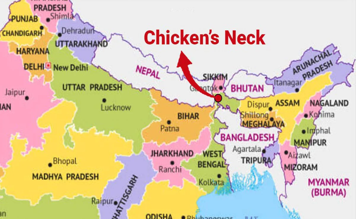
The Siliguri Corridor, often referred to as the “Chicken’s Neck,” is arguably the most terrifying piece of geography for Indian defense planners. Imagine a mighty elephant held by a thread; that thread is Siliguri.
Recent satellite imagery revealing aggressive Chinese infrastructure buildup in Bhutan’s Doklam plateau has reignited New Delhi’s oldest fear. In the event of a full-scale conflict, could the People’s Liberation Army (PLA) choke this narrow corridor and cut off the entire Northeast India—Arunachal Pradesh, Assam, Manipur, and others—from the mainland within 48 hours?
This analysis decodes the vulnerability of the Chicken’s Neck and why protecting it is the Indian Army’s highest priority.
The Geography of Fear
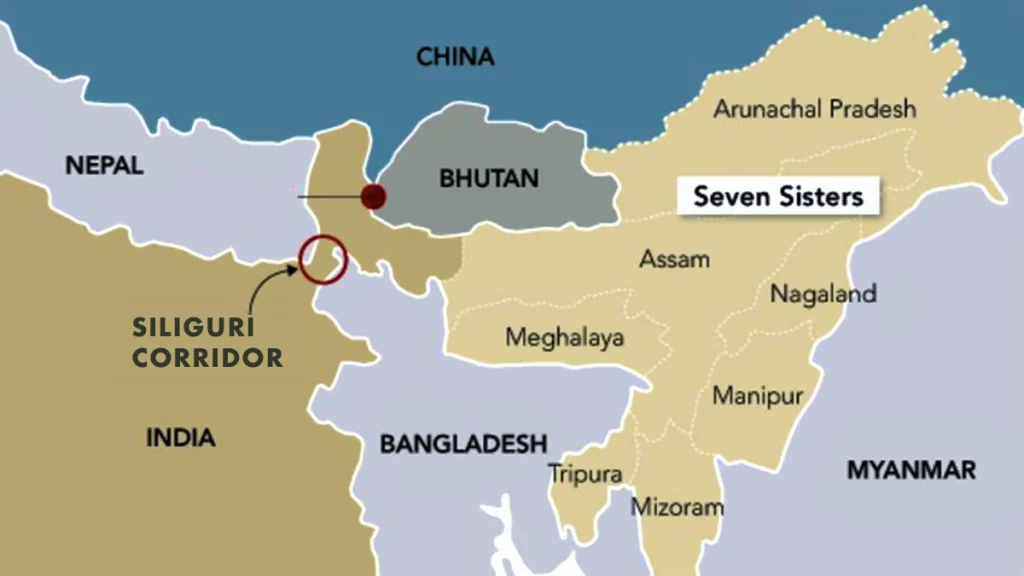
To understand the stakes, look at the map. The Siliguri Corridor is a narrow strip of land in West Bengal, squeezed between Nepal to the north, Bangladesh to the south, and Bhutan to the northeast.
Width: At its narrowest point, it is just 20 to 22 kilometers wide.
Importance: Every road, every railway line, and every oil pipeline supplying the 45 million people of Northeast India passes through this choke point. Even the military supplies for the Tawang border must flow through here.
If this artery is blocked, the Northeast is isolated. It is the geopolitical equivalent of a jugular vein.
The Doklam Connection: Why China Wants It
This explains why the 2017 Doklam Standoff between Indian and Chinese troops was so critical. The Doklam plateau belongs to Bhutan, but China claims it.
The High Ground: Doklam overlooks the Siliguri Corridor. If China controls Doklam, it gains the “High Ground” advantage. They could position artillery and missiles that directly target the highway and railway lines in Siliguri.
The Strategy: In a war, China wouldn’t need to capture territory deep inside India. They would simply need to bomb the corridor from Doklam, creating a blockade.
The Nightmare Scenario: “Cut and Isolate”
Defense analysts often simulate a “Two-Front War” scenario.
The Pincer Move: While Pakistan keeps India busy on the Western front, China launches a swift offensive from the Chumbi Valley (Tibet).
The Blockade: Chinese special forces or heavy artillery target the bridges and rail networks in the Siliguri Corridor.
The Result: Within hours, reinforcement lines to Arunachal Pradesh are cut. The Indian Army units already in the Northeast would be left to fight without new supplies of fuel or ammunition from the mainland.
This is not fear-mongering; it is the standard PLA doctrine of “Severing the Head.”
India’s Counter-Strategy: Hardening the Shell
New Delhi knows this vulnerability better than anyone. Over the last decade, India has activated a multi-layered defense and alternative connectivity plan.
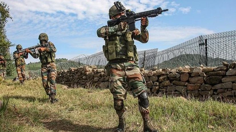
1. Heavy Military Presence The corridor is now one of the most heavily militarized zones in the world. The Indian Army’s 33 Corps (based in Sukhna, near Siliguri) is specifically tasked with defending this strip. Recent deployments include S-400 missile batteries to shoot down Chinese jets before they can target the corridor.
2. The Nepal & Bangladesh Factor India is building “Strategic Depth.”
Railway Links: New rail links through Bangladesh (like the Agartala-Akhaura link) allow India to bypass the Chicken’s Neck if needed.
Energy Grid: An India-Bangladesh friendship pipeline now supplies diesel, reducing the load on the corridor.
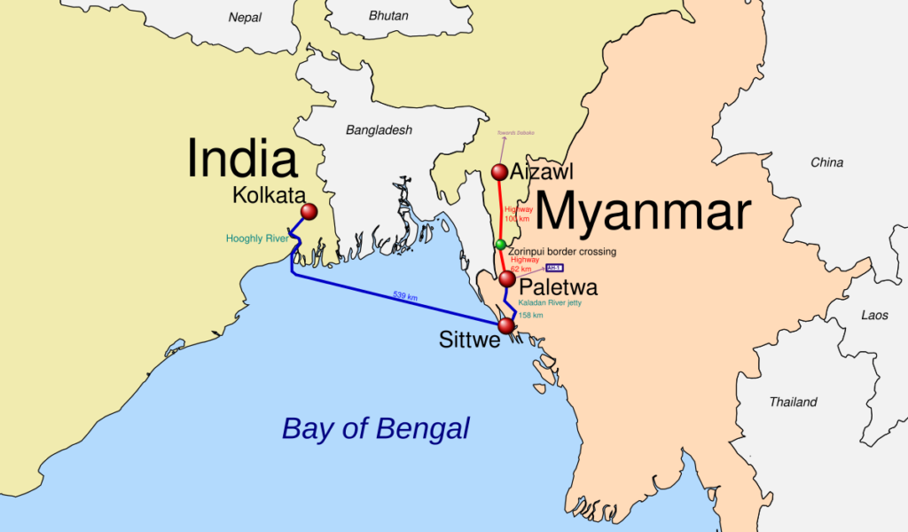
3. The Kaladan Multi-Modal Project: This is the ultimate backup plan. The Kaladan project connects the port of Kolkata to the Sittwe port in Myanmar, and then up the river to Mizoram.
The Benefit: Even if the Siliguri Corridor is blocked, India can send troops and supplies to the Northeast via the sea route through Myanmar.
The “Free Trade” Risk
However, a new challenge has emerged. The corridor is not just a military zone; it is a trade hub. With Nepal and Bhutan using it for transit, it is crowded. China is trying to woo Bangladesh and Nepal to build influence on both sides of the corridor (“The Nepalese side and the Bangladeshi side”). This diplomatic encirclement is just as dangerous as the military one.
Conclusion
The Siliguri Corridor remains India’s Achilles’ heel. While the military defenses are robust, geography is a cruel mistress. The survival of India’s territorial integrity depends on keeping this 22 km strip open. As China builds villages in Bhutan and highways in Tibet, the “Chicken’s Neck” remains the most dangerous place on the map—a place where a local skirmish could trigger a national crisis.
Related Analysis: [Read how China’s Water Bomb on the Brahmaputra further threatens the Northeast.]