Strategic Intelligence Report | By Wish, Analyst
Frontier Highway India 2026:
The Intelligence Brief
As we conclude December 2025, the geography of the Indo-Pacific conflict has shifted from the high seas to the rugged, vertical heights of the Eastern Himalayas. For decades, the lack of last-mile connectivity in Arunachal Pradesh was considered a “strategic defense” to prevent rapid enemy incursions.
However, the lessons from the 2025 border friction and the massive infrastructure buildup by the Chinese Western Theatre Command (WTC) have shattered that legacy. New Delhi has responded with the most ambitious infrastructure project in the nation’s history: the Frontier Highway India 2026 roadmap.
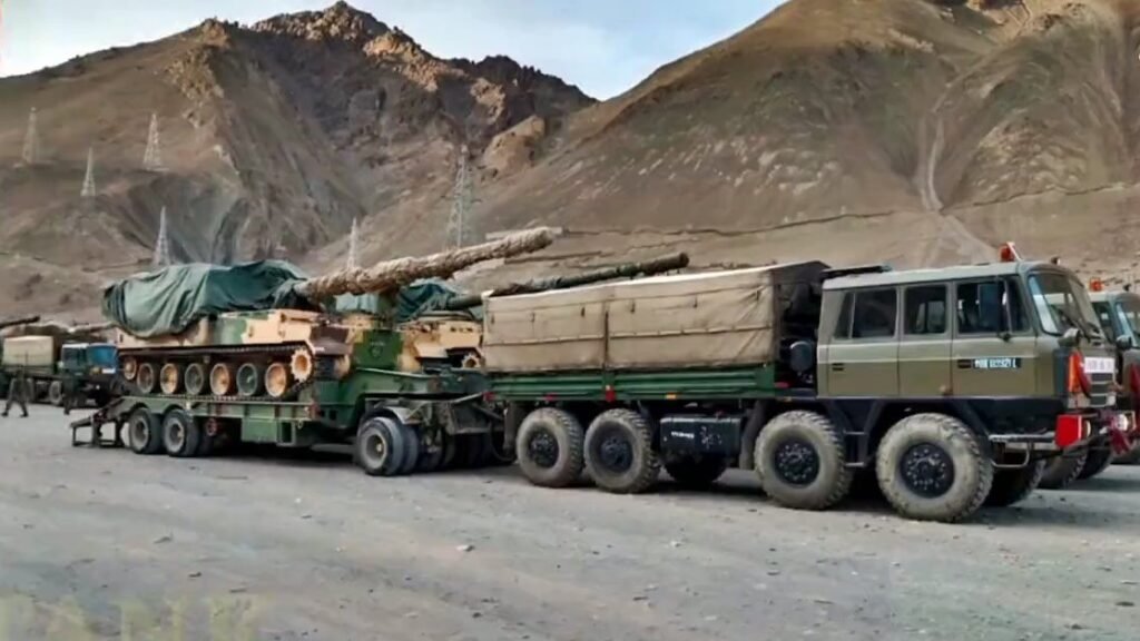
Spanning nearly 2,000 kilometers along the Line of Actual Control (LAC), the Frontier Highway is not just a road; it is a strategic spine designed to move heavy artillery, T-90 tanks, and rapid-reaction teams across valleys that were previously isolated. Simultaneously, the approval of the Brahmaputra Underwater Tunnel—a project of immense engineering complexity—ensures that the supply lines from the mainland remain “Unsinkable” even during an all-out aerial bombardment.
This report decodes how these two pillars are creating a multi-layered Himalayan fortress to neutralize the “Xiaokang” villages of China.
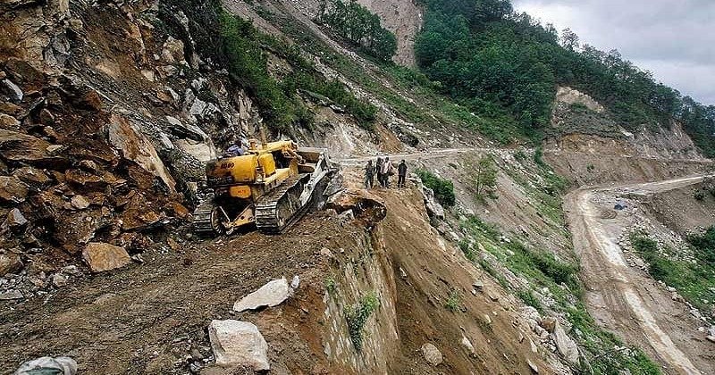
1. The Frontier Highway: The 2,000 km Strategic Spine
The Frontier Highway India 2026 project, also known as the NH-913, is being fast-tracked by the Border Roads Organization (BRO) and the Ministry of Road Transport and Highways (MoRTH). Starting from Mago-Thingbu and stretching to Vijayanagar, it runs parallel to the LAC, often within 20-30 kilometers of the border.
Ending the ‘Vertical Isolation’
Historically, Arunachal’s valleys were separated by massive mountain ridges, meaning troops in one valley could not reinforce those in the next without returning hundreds of kilometers to the plains. The Frontier Highway solves this:
Lateral Connectivity: It connects the Kameng, Subansiri, Siang, Dibang, and Lohit valleys.
Response Time Reduction: What once took 15 hours of treacherous mountain driving will, by late 2026, take less than 4 hours, allowing the Indian Army to shift its strike corps laterally to counter any Chinese “salami-slicing” attempt.
Heavy Weaponry Logistics: The highway is being built to “Military Specifications,” capable of supporting the weight of the K-9 Vajra Howitzers and the upcoming Project Kusha mobile missile batteries.
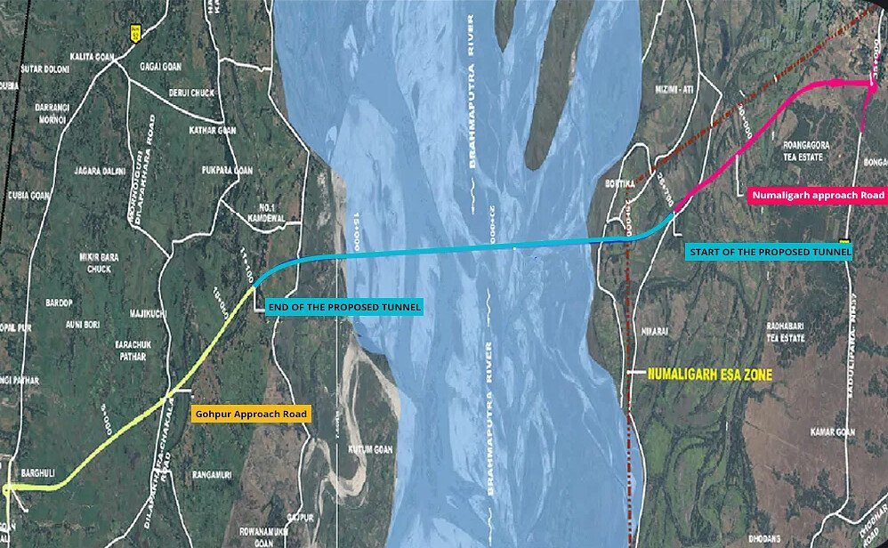
2. The Brahmaputra Underwater Tunnel: The Unsinkable Lifeline
While the Frontier Highway secures the border, the Brahmaputra Underwater Tunnel secures the access to it. As of late December 2025, the technical feasibility and tendering for India’s first underwater rail-road tunnel have reached a critical milestone.
Why a Tunnel Over a Bridge?
In a high-intensity conflict, bridges like the Dhola-Sadiya or the Bogibeel are the first targets for Chinese long-range missiles and bombers. If these bridges are destroyed, the entire Indian defense in the Eastern Sector is cut off from the mainland.
Strategic Stealth: Built deep under the riverbed, the tunnel is practically immune to satellite detection and aerial bombardment.
Dual-Mode Capability: The 12-km long tunnel will feature separate tubes for rail and road. This allows for the rapid induction of entire infantry divisions via rail and the continuous flow of heavy ammunition and fuel via road tankers.
2026 Operational Milestone: Current progress suggests that the first “Boring Phase” will conclude by late 2026, ensuring that India’s Integrated Theatre Commands India 2026 have a secure logistics artery that the enemy cannot sever.
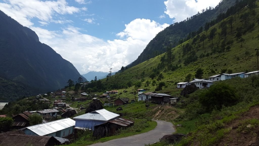
3. The Demographic War: Vibrant Villages vs. Xiaokang Strategy
Infrastructure is only half the battle; the other half is people. China has built hundreds of Xiaokang (Model Villages) along the LAC, which serve as dual-use outposts for civilians and soldiers. India’s response is the Vibrant Villages Program (VVP).
Settling the Frontier
Under the 2025-26 VVP roadmap, the government is pouring billions into border villages like Kibithu and Tuting.
Reverse Migration: By providing 4G connectivity, high-speed roads, and sustainable tourism opportunities, India is encouraging people to stay in border regions.
First Line of Intelligence: A populated border is a monitored border. These “Vibrant Villages” act as the eyes and ears of the Indian Army, providing real-time intelligence on Chinese movements, a crucial factor during the Operation Sindoor drills of late 2025.
Infrastructure Synergy: The Frontier Highway India 2026 provides the logistics required to sustain these communities, ensuring they are not just outposts, but thriving economic hubs.
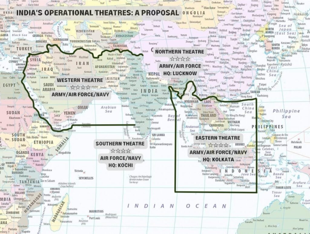
4. Integration with Northern Theatre Command (Lucknow)
The true power of the Frontier Highway India 2026 lies in its integration with the Integrated Theatre Commands India 2026 framework.
The Command-and-Control Link
All border roads and the Brahmaputra Tunnel will be data-linked to the Northern Theatre Command (NTC) in Lucknow.
Rapid Deployment: Utilizing the newly secured logistics pacts like the RELOS Agreement India, India can now move assets from the Arctic or maritime sectors to the Himalayan frontier with unprecedented coordination.
Sky Shield Integration: The highway will host mobile launchers of Project Kusha Sky Shield, creating a mobile, moving air-defense net that the Chinese J-20s cannot easily track or destroy.
5. Geopolitical Rivalry: The Infrastructure Arms Race
The competition between India and China along the 3,488 km LAC is now a race of engineering. While China had a 20-year head start, India’s “Project 7” (the bridge and tunnel initiative) and the Frontier Highway have closed the gap in record time.
Comparison Table: LAC Infrastructure 2026
| Feature | India’s Frontier Roadmap (2026) | China’s LAC Infrastructure |
| Primary Highway | Frontier Highway (2,000 km) | G-219 Highway |
| River Crossing | Brahmaputra Underwater Tunnel | Bridges over Yarlung Tsangpo |
| Border Villages | Vibrant Villages (700+) | Xiaokang Villages (600+) |
| Connectivity Type | Lateral (Connecting Valleys) | Radial (From Base to LAC) |
| Logistics Nodes | Project Seabird & Karwar Link | Lhasa & Shigatse Hubs |
6. Technical Challenges: Engineering at 15,000 Feet
Building the Frontier Highway India 2026 is an engineering nightmare. The BRO is dealing with seismic zones, fragile Himalayan ecology, and extreme weather.
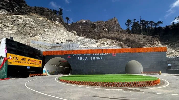
The Sela Tunnel Lesson: The success of the Sela Tunnel has provided the blueprint for the Frontier Highway. By using the New Austrian Tunnelling Method (NATM), India is now building all-weather roads through passes that were previously closed for 6 months a year.
Environmental Balance: The 2026 roadmap includes “Green Highway” features, using bio-fencing and stabilized slopes to ensure that the infrastructure does not trigger landslides, a common problem that has plagued Chinese infrastructure on the Tibetan plateau.
Conclusion: The End of India’s Strategic Defensiveness
The completion of the Frontier Highway India 2026 and the commencement of the Brahmaputra Underwater Tunnel mark the end of an era. India is no longer afraid to build roads to its borders. By creating this Himalayan fortress, New Delhi has effectively neutralized China’s infrastructure advantage.
These projects ensure that any attempt to alter the status quo along the LAC will be met with a swift, massive, and unified Indian response. The mountains are no longer a barrier for India; they are its greatest defensive asset.
Recommended Reading: India’s Defense Pillars
To understand how the Frontier Highway fits into India’s broader 2026 strategic roadmap, explore our related intelligence reports:
Command Reform: Integrated Theatre Commands India 2026: The Military Revolution
Sky Shield: Project Kusha India Sky Shield 2026: The Indigenous Iron Dome
Stealth Air Power: India AMCA 5th Gen Stealth Fighter: The 2026 Roadmap
Maritime Defense: Operation Sankalp 2.0 Red Sea: India’s Role as Net Security Provider