By Wish | Strategic Intelligence
The Eye in the Sky
Imagine a stranger sitting on your balcony with a high-powered telescope, recording everything happening inside your living room. That is exactly what the Coco Islands represent for India today.
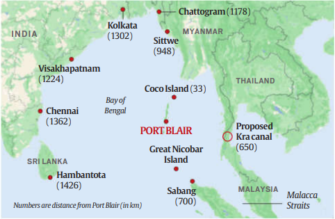
Located in the Bay of Bengal, these islands belong to Myanmar politically. But strategically, defense analysts and satellite intelligence suggest they have become a forward operating listening post for Beijing.
Just days after we analyzed India’s Great Nicobar Project, it is critical to look North. A mysterious runway extension and new radar domes have set off alarm bells in New Delhi.
Strategic Proximity Matrix
(Why geography makes this island dangerous)
| Target Location | Distance from Coco Islands | Strategic Risk |
| Landfall Island (India) | 55 km | Immediate visual surveillance. |
| Diglipur (North Andaman) | 60 km | Monitoring of Indian airstrips. |
| Port Blair (Command HQ) | 280 km | Interception of naval communications. |
| Odisha Coast (DRDO) | 1,200 km | Tracking of Agni/BrahMos missile trajectories. |
1. The “Nehru Gift” Myth vs. Reality
Before we decode the threat, we must address the most googled question in India: “Did Jawaharlal Nehru gift the Coco Islands to Myanmar?”
This is a persistent internet myth.
The Fact: The Coco Islands were historically part of the British Raj via Burma (Myanmar), not India. When Burma separated from British India in 1937, the islands went with them. There is no record of an official “transfer” or “gift” in 1950.
The Real Failure: While it wasn’t a gift, Indian leadership in the 1950s did underestimate the strategic value of these islands, treating them as negligible rocks. That oversight is now haunting the Indian defense establishment in 2025.
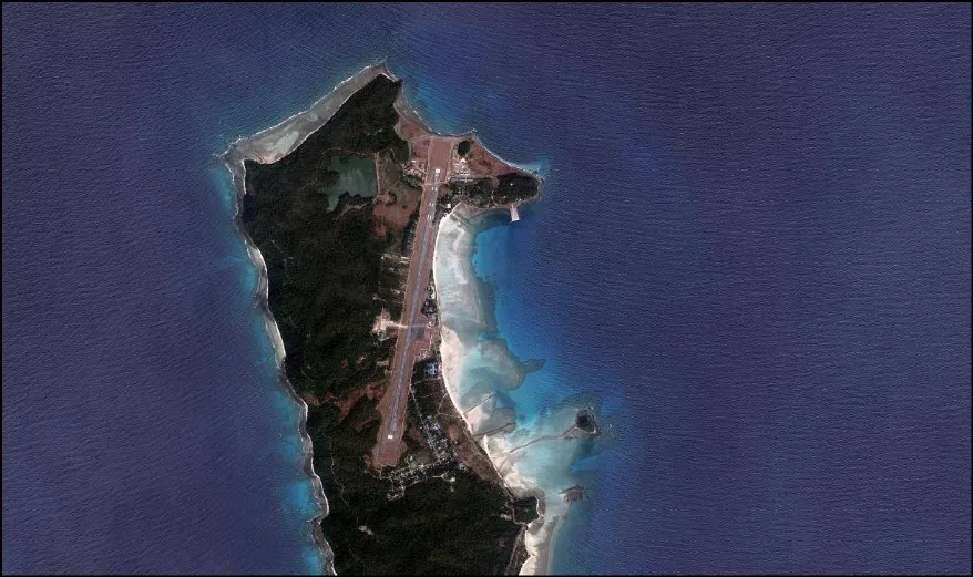
2. OSINT Analysis: What the Satellites See
For years, the “Chinese Base” theory was dismissed as conspiracy. But recent open-source intelligence (OSINT) from Maxar Technologies has made it undeniable.
The Runway Expansion
Satellite imagery from January 2023 onwards shows a massive upgrade.
Old Runway: 1,300 meters (Suitable for small planes).
New Runway: 2,300 meters (Suitable for military transport aircraft and heavy surveillance drones).
The Radar Domes
More alarming than the runway are the two large radomes (radar covers) spotted on the southern tip. Myanmar’s junta does not have the money or the technology to build such advanced SIGINT (Signals Intelligence) facilities. The fingerprints point clearly to Beijing.
3. Why China Wants This Rock (The Mission)
Why is China investing millions in a remote island owned by Myanmar? The answer lies in Data Espionage.
A. Tracking DRDO Missiles
India tests its Agni and BrahMos missiles from the Abdul Kalam Island (Odisha) towards the Bay of Bengal. The radars on Coco Islands can track the trajectory, speed, and telemetry data of these missiles. It’s like stealing India’s nuclear homework.
B. Hunting Submarines
As India deploys nuclear submarines (INS Arihant) in the Bay of Bengal, the listening posts at Coco can record their “acoustic signatures.” If China knows what an Indian submarine sounds like, they can hunt it down in a war.
4. Strategic Implications: The Bay of Bengal Dilemma
This development changes the security architecture of the region. The Bay of Bengal has traditionally been India’s “safe zone” compared to the Arabian Sea.
With a Chinese listening post at Coco, the element of surprise is lost.
Tri-Service Threat: The Andaman and Nicobar Command (ANC), India’s first tri-service command, is now under direct observation. Every ship leaving Port Blair is likely being logged.
The Myanmar Factor: China is using its influence over the Myanmar Junta to secure this access. India finds itself in a diplomatic bind—it cannot alienate Myanmar (due to border insurgency issues) but cannot ignore this violation of trust.
5. India’s Counter-Move: Operation Blindfold
New Delhi is aware of the “Spy Next Door.”
Diplomatic Pressure: India has repeatedly raised this with the Myanmar military junta. However, Myanmar is heavily dependent on Chinese protection at the UN, making them reluctant to act.
INS Baaz: India has upgraded its own naval air station, INS Baaz, at Campbell Bay. If Coco is the “Eye,” Baaz is the “Shield.” India is also deploying electronic jamming technology to block the sensors on Coco Islands during critical missile tests.
Analyst’s Verdict: The Silent Watcher
The Coco Islands mystery is a reminder that in geopolitics, geography is destiny. A cluster of small islands, ignored for decades, has now become a critical node in the spy war between Asia’s giants.
My Assessment:
China will not place troops here openly. Instead, they will use it as a “Technological Outpost.” As India builds its “Iron Curtain” in Nicobar, it must constantly look over its shoulder at the silent watcher in the North. The Bay of Bengal is no longer a peaceful sea; it is a crowded room full of spies.
Read Next: [How India’s Great Nicobar Project is the direct answer to this threat.]